KQGIS SDK
A powerful, cross-platform GIS development toolkit designed for high-performance geospatial applications.
Built on a C++ core and integrated with 2D and 3D capabilities, it enables developers to manage and analyze massive spatial datasets with cutting-edge GIS big data technologies.
Designed to support a wide range of development environments—including Qt, Java, and .NET—KQGIS SDK is ideal for building everything from lightweight applications to large-scale enterprise GIS systems.
Key Features of KQGIS SDK

Cross-Platform Compatibility
- Built on a robust C++ engine with support for Qt, Java, and .NET development.
- Seamlessly runs across diverse software and hardware environments, including multiple CPU and GPU architectures.
- Supported CPUs: x86, Power, ARM, MIPS, Alpha—including domestic chips like Feiteng, Loongson, Shenwei, Zhaoxin, Huawei Kunpeng, and Zhongke Haiguang.
- GPU support includes NVIDIA, AMD, and domestic options like Jingjiawei.
- Stable 3D performance through OpenGL optimization, custom drivers, and in-house rendering enhancements.
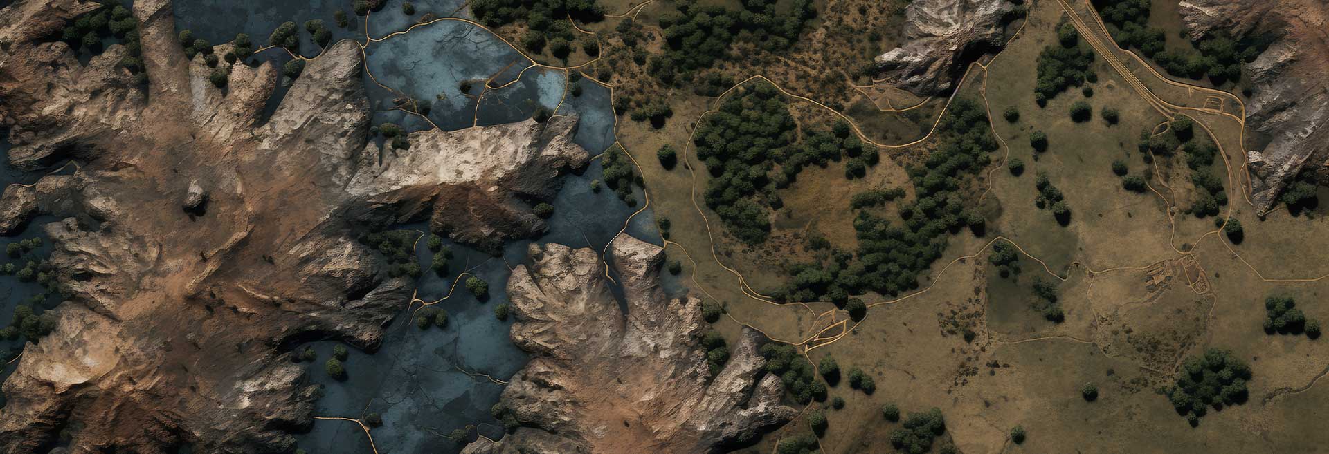
Integrated 2D & 3D GIS Capabilities
- Unified platform for 2D and 3D spatial data development—no need for separate systems.
- Instantly visualize 2D data in 3D scenes without conversion.
- Easily build and render point, line, and polygon features in 3D environments.

Advanced GIS Algorithm APIs
- Access a comprehensive library of GIS algorithms, including:
- Map rendering
- Nautical chart symbolization
- Hydrological modeling
- Geostatistical analysis
- Designed to meet the technical needs of beginner to expert developers.

Extensive Development Examples
- Comes with hundreds of real-world sample projects:
- Rendering techniques, geometric visualizations, spatial engine interactions, and more.
- Includes detailed guides, runtime effects, and best practices to support third-party development.

Multi-Source Spatial Data Management
- Supports access to various commercial and open-source spatial databases:
- Commercial: Oracle, SQL Server, Access
- Open-source: PostgreSQL, MySQL, MongoDB
- Domestic: Dameng, Hango, Renmin Jincang
- Designed to streamline multi-source spatial data workflows in large-scale GIS systems.
Related Products
A comprehensive GIS data management software that integrates mapping, image processing, analytics, and data management into an intuitive user interface.
A high-performance & enterprise-class system, which enables GIS applications and service publishing and sharing.
A field-ready GIS solution that allows users to collect, analyze, and share spatial data in real time.
It provides advanced 3D visualization and spatial analysis tools, enabling users to interact with geospatial data in a dynamic 3D environment.
A development toolkit that empowers developers to create custom GIS applications tailored to specific industry needs.
A remote sensing platform designed for high-precision satellite imagery and data processing applications.
It leverages artificial intelligence to enhance GIS applications, providing predictive analysis and automation capabilities.
Unlock Your Business Potential
For any inquiries or assistance, please don’t hesitate to contact us via email or phone.