Menu
Products
KQGIS Desktop
A comprehensive GIS desktop application and development platform designed for efficient spatial data production and management.
Learn More
KQGIS Server
A powerful platform for publishing, managing, and developing geospatial data and services.
Learn More
KQGIS Mobile
A professional GIS-embedded mobile software development platform by KQ GEO Technologies, Co. Ltd., designed to leverage the capabilities of mobile devices.
Learn More
KQGIS 3D
KQGIS 3D is a leading 3D GIS platform which is developed independently by KQ GEO.
Learn More
KQGIS SDK
A powerful, cross-platform GIS development toolkit designed for high-performance geospatial applications.
Learn More
KQRS
AI Interpretation Software is an advanced remote sensing analysis platform developed through a deep understanding of artificial intelligence technologies and the specific needs of the remote sensing industry.
Learn More
KQGIS AI
KQGIS integrates AI-driven applications and provides six major categories of analytical algorithms, covering: spatial analysis, cluster analysis, 3D analysis, classification analysis, network analysis, association rule analysis, and geostatistical analysis—a total of eight types of analytical algorithms.
Learn More
Solutions
Natural Resources
KQ GEO TECHNOLOGIES Co., Ltd. has more than 20 years of rich experience and technical accumulation in the industries of natural resources, spatial planning, surveying, mapping and geographic information.
Learn More
Agriculture
Based on the actual needs of modern agricultural production, as well as KQGIS platforms, KQ vigorously creates a smart agriculture solution agricultural management departments, large farms and agricultural parks by integrating a number of emerging technologies such as Internet and IoT.
Learn More
Smart City
Our Smart City solution adopts the technologies, such as geospatial information, cloud computing and IoT to sense, analyze, and integrate critical city information in different fields to intelligently respond to various needs for governments, enterprises, and the public.
Learn More
Water Conservancy
Relying on KQGIS platforms, KQ has developed a series of systems for water census, water conservancy projects, water resources management, flood prevention and drought relief.
Learn More
Ecological Environment
In recent years, the Chinese government has introduced a series of policies to promote high-quality development in the ecological protection and restoration sector.
Learn More
Emergency Safety Supervision
In the field of safety supervision and emergency response, the KQGIS platform provides customers with comprehensive technical support systems covering the entire workflow—including safety monitoring, disaster surveillance, early warning, emergency command, and information management.
Learn More
Housing and Construction
With a variety of KQ systems and devices for survey, registration, information aggregation and sharing, and value-added services related with real estate, we are dedicated to providing an advanced, efficient and convenient solution of unified real estate registration.
Learn More
Ocean
To solve issues such as incomplete ocean observation data, inconsistent platforms, and scattered information sources, KQ leverages cutting-edge technologies including portal systems, cloud computing, big data, and 3D GIS.
Learn More
Forestry
With a variety of KQ systems and devices for survey, registration, information aggregation and sharing, and value-added services related with real estate, we are dedicated to providing an advanced, efficient and convenient solution of unified real estate registration.
Learn More
News
Resources
Brochures
Videos
About
Introduction
Qualification & Honor
Partners
Contact Us
✕
No results
See all results
Resources
Brochures
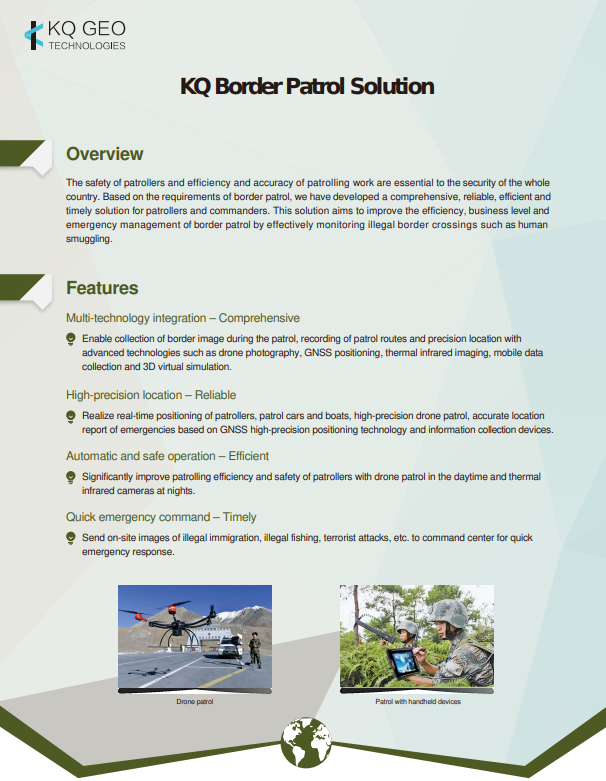
KQ Border Patrol Solution
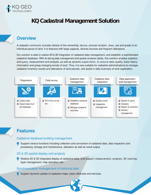
KQ Cadastral Management Solution
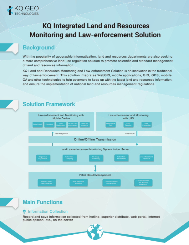
KQ Integrated Land and Resources
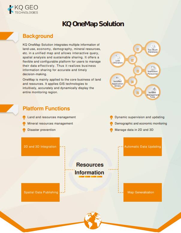
KQ OneMap Solution
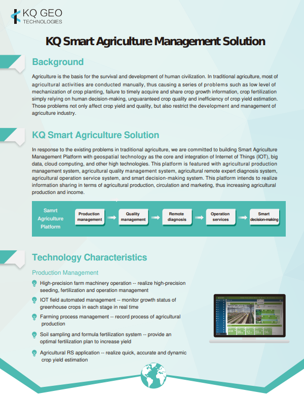
KQ Smart Agriculture Management Solution
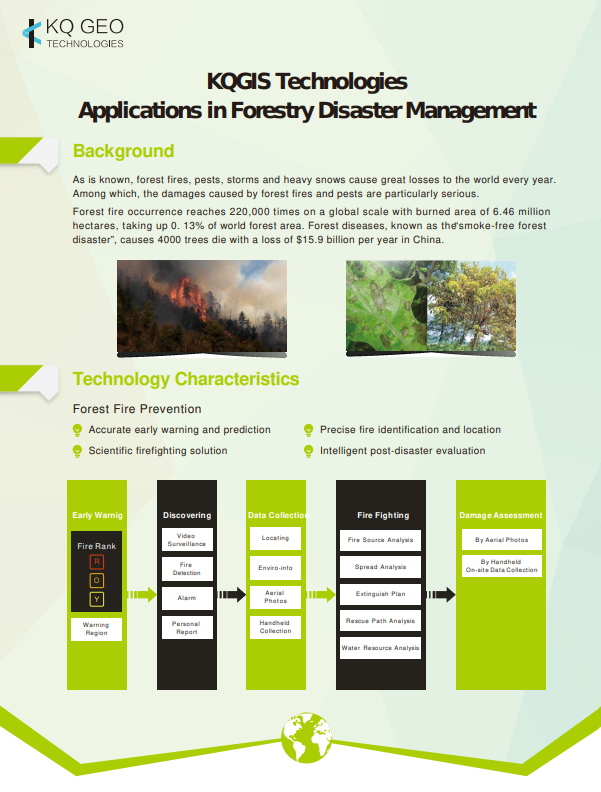
KQGIS Applications in Forestry Disaster Management
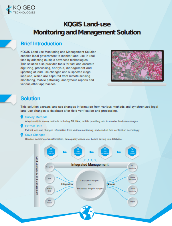
KQGIS Land-use
KQGIS Platform